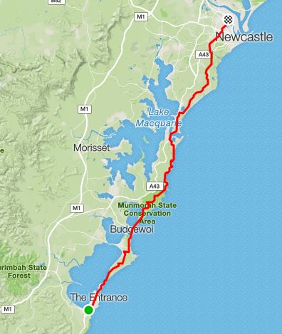
Each year I like to try some sort of challenge over the summertime when the days are at their longest and I have a few days off over the Christmas break to recover. This year just to see if it was possible I gave myself the challenge of running from my place at Shelly Beach on the Central Coast to the Telligence office at East Mayfield in Newcastle in time to start work on Christmas Eve. And just to make it a bit harder (and also a bit safer) I was going to try and stay off the main roads as much as possible, utilising bike tracks, fire trails, bush trails and the beaches as I plot my way north.After a couple of hours sleep (I was out the night before) I got up just before midnight, grabbed my pre-packed running pack and headed out the door. Clean clothes and breakfast were waiting for me in the office, so I was travelling pretty light: running pack, 2ltr bladder (carrying 1.5ltr at this stage), 2 Nutella & 1 jam sandwich, a handful of gels, a spare running headlamp + a heap of batteries, minimal first aid kit including a space blanket, 1 long sleeve shirt, ID & cash and that was it. Just enough to get me to Newcastle with enough gear to keep me warm in case I got injured or stuck somewhere.I set off dead on midnight and the first part of the run saw me wind my way through the streets of Long Jetty startling a drunk guy who was on his way home and stumbling across the road when he caught sight of me running up towards him, he froze thinking he was about to be attacked and then as I ran past saying "evening" I heard grunted "runner <huhh> what <huhh>". There were a few more people staggering home down at The Entrance, but once I was across the bridge there was no one. I followed the bike track north as far as it goes to Magenta, but when it came to an end I had no choice but to run on the side of Wilfred Barrett Drive until I got to the Red Gum Forest walking tracks. As everyone knows Wilfred Barrett is haunted, so for a bit over 2km's I ran down the side of the haunted road with nothing but dense bush on either side of me and the occasional car speeding past. I'm happy to report that there were no signs of the ghost by the time I got to the track head and into the Red Gum Forest. It was good to leave the road and disappear into the dark and foreboding bush, which was also full of spiders happily making their webs across the track. I followed the bush tracks which meander their way north running parallel to Wilfred Barrett drive before coming out of the bush and joining back up with the road near the cemetery (this is why there are ghost stories about that road…).The next part of the run wasn't overly exciting, shared pathway and the old Rutile road saw me through to Budgewoi and then it was the next unavoidable 3k stretch of road from Budgewoi to Elizabeth Bay, but this section as far as I know isn't haunted and only 3 cars passed me the entire time (this may be because it was now 2am). From here the run was going to get more exciting, I filled up my bladder with the full 2ltrs of water, got my maps out of my pack and set off into Munmorah State Conservation Area. My reasoning for doing this was that I could avoid running on the edge of the long, hilly and very fast Pacific Highway. Instead I'd plot my way through unknown territory with a free brochure (containing a map) and several printed out google maps and satellite images because it's not like all those tracks were marked.The first part through the park was very pleasant, it was almost a full moon and I was following the roads as they undulated north, there was no one else out, no cars or people and instead all I saw were lots of frogs, possums and terrified wallabies who'd disappear crashing into the bush. I left the road according to my map and compass to continue on an unsignposted fire trail north before reaching the edge of the conservation area and then continuing on tracks through the bush and down to the sand of Moonee Beach. The salt mist makes running with a headlamp on the beach really hard, it's like running through thick fog with the light bouncing back into my eyes so I could only see a few metres in front of me. Still it was enough to make out the headland to the north and then after a little bit of searching find the trail up and over the headland. Over the headland I went and headed into Catherine Hill Bay, running through the huge new development going on there, unfortunately it was far too dark and large for me to see anything more than the large metal fences which were keeping me from wandering off into the construction zone.
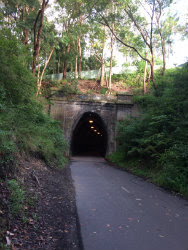
Down the main street of Catho I ran at 3:30am, even the pub was closed and the town was deserted, all the sensible people were in bed. I cut through the cemetery at the edge of town and ran onto the sand heading north to the next headland. This next section was slow going, lots of steep slippery climbs which even my trail shoes were having trouble with after all the rain, plus a heap of intersecting trails meant I had to keep on referring to the maps (now just printouts of google satellite images). I got a couple of txts at this stage, people checking I was still alive and moving north (I had let a lot of people know what I was up to in case something did go wrong). But all was good and I had phone reception at the top of the climbs, not so much when I headed down into National Park with thick undergrowth and giant ferns beside the tracks. It made it all very exciting, but I was glad that all the map calculations had paid off and I made it to the little bridge which crosses the creek that goes down to Pinny Beach. Across the bridge followed by a steep climb up and I'd reached the streets of Caves Beach.It was now 4:15am and there were starting to be a few signs of very early morning activity in the streets of Caves Beach, people getting their boats ready for the day, a couple of early morning workers and even some early morning walkers as I got closer to Swansea. The sun came up as I was crossing Swansea Bridge and I stopped to take a few photos and send of txt's to say I'd made it back into civilization and the next section was straightforward. The bike track through Swansea was very pleasant, before a bit of road running and then I turned off and followed a dirt track which would eventually lead me to my nemesis THE FERNLEIGH TRACK. I got onto the track at about the 3k mark, so with 12 more kilometres of track running. Sure the track is nice and smooth, well made, very scenic but it is also a constant uphill run until the last couple of k's. Plus it's so incredibly boring on the feet and mind after having the fun of plotting my way through the bush this was just boring. Bike rider, Bike rider, more bike riders... I was not enjoying my time on Fernleigh and was honestly just counting down the k's until I'd be off the track. To be fair I've only used this track twice, the previous time was a year ago when I wanted to see if I could ride to work - I could. I'd already been running 6hrs covering 55kms so my legs were pretty fatigued and this constant uphill was not helping the situation. I was incredibly relieved when I got off the track at Adamstown, and after refilling my bladder at a nearby train station I set off on the final section of the run.I used google maps on my phone to plot me through the maze of Newcastle backstreets (I am completely terrible at navigating Newcastle), then it was onto a section that I did recognise as I cut through the Tafe at Tighes Hill, took a phone call from a friend who was checking up on me (while still running) and finally reached the office 73.6kms and 8hrs later, with plenty of time to get cleaned up, cook some protein pancakes on @officesandwichtoaster and be ready to start work at 8:30.
Would I run to work again? No, probably not, but only because I've already done that and I need a bigger challenge for next year. I am open to suggestions....


Comments
Post a Comment